Location: Ashbury Park, north Timaru
Access: Public park
Associated years: 1940 to 1945, 1942 photograph
Associated people/groups: Combined Washdyke and Timaru Home Guard, Timaru Battalion Home Guard, local men not serving overseas
South Canterbury Museum has a 1942 photograph of the Combined Washdyke and Timaru Home Guard. DigitalNZ lists many names associated with the image, including local men from Washdyke and Timaru. The museum also holds a Timaru Battalion Home Guard roll book covering 1940 to 1945.
The Home Guard is essential because it brings ordinary local people into the tour.
Many Home Guard members were men too old, too young, medically unfit, reserved for essential work or otherwise not overseas. South Canterbury Museum also holds 27 volumes of home-defence clippings covering August 1940 to August 1945, with subjects including Home Guard, Emergency Precautions Service, Timaru Fire Emergency Service, Women’s War Service Auxiliary, Women’s Land Army, blackout trials, food rationing, defence building and air raid shelters.
Find a WuHoo: Think of a park not as leisure space, but as a place where local defence, drill and readiness could be organised.
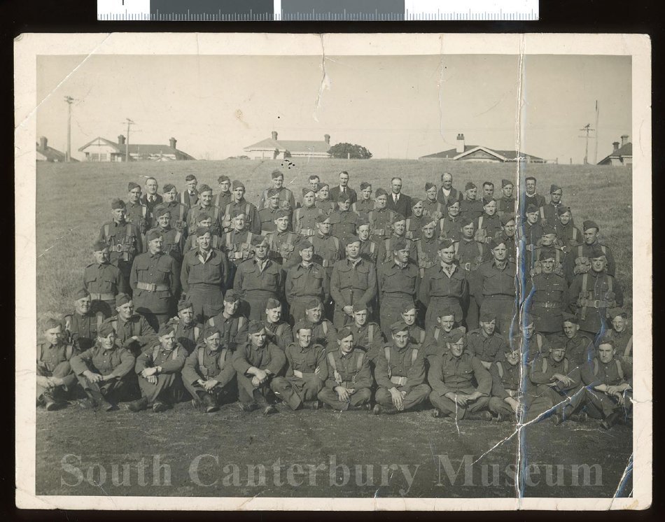
The "Combined Washdyke and Timaru Home Guard, 1942", taken by S A Bremford. Depicts several rows of men posed on the grass at Ashbury Park, Timaru, in their Home Guard uniforms. South Canterbury Museum 2017/129.02
Some of the men attributed to the home guard: Ted Alexander; Percy Applegarth; Mick Bailey; Jack Cassidy; Jim Chiles; Peter Couper; Norman Daniels; Ernie Darling; Graham Davidson; Frank Dawe; Elms; Ted Falvey; Rusty Fidler; Bill Field; Arthur Goodman; Clarry Hawkey; Keith Hunt; Alby Ingram; Bil Kellahan; Gordon Kelman; Alf King; Arthur Edward (Ted) King; George King; Jock King; George Linton; Walter Mackay; A C Martin; Hector McAuley; Ernie McRae; Harry Newman [?]; John Newman; Norman; Ivan Pearce; Bill Pickard; Eric Preen; Bert Price; Eric Robinson; Jack Robinson; Alex Ross; Bill Smith; Jack Strachan; Sumpter; Charlie Thompson; Ted Tregenza; Bob Vincent; Wardell; Jim Wilson.

1911. Section of Miscellaneous Plans - Borough of Timaru, South Canterbury. R25538727. Borough of Timaru, South Canterbury. NZ Heritage Maps Platform, https://maps.recollect.co.nz/nodes/view/336

Timaru from the Air when Waimataitai Creek still ran through what is today Ashbury Park. You can see how close the Caroline Bay Tea Rooms used to be to the sand. For many of the aerial photographs, while Doug Mill was piloting the plane his wife Audrey was leaning out of the open cockpit with a camera. Between 1927-1937. Auckland Libraries Heritage Collections FDM-0690-G - Creative Commons Licence: Attribution CC BY

In this map you can see the waimataitai lagoon before it was drained and turned into a park. The stream was piped underground and can be seen at the golf course. Miscellaneous plans - borough of timaru, south canterbury, 1911 - t.N. Brodrick, chief surveyor canterbury ndhadeliver.Natlib.Govt.Nz/ie31423732

What was once a lagoon, is now Ashbury Park. Aerial view of Timaru, showing Caroline Bay, harbour and town between 1920 and 1939. - Auckland Libraries Heritage Collections FDM-0690-G

Wise’s map of Timaru ca.1954. To the best of our knowledge the image is free of copyright, but legal opinion should be sought to establish certainty before publishing the image in any way or using it for commercial purposes. https://christchurchcitylibraries.com/Heritage/Maps/479779
New Zealand. Ministry of Works, South Canterbury Museum 2009/169.10