
By Guest writer: Graeme Gunn 2025
Formerly employed by Opus International Consultants, which later became WSP
Graeme helped lead the massive project to digitise the nation’s historic aerial survey films for Land Information New Zealand, safeguarding nearly 650,000 fragile images originally captured by New Zealand Aerial Mapping. Joining the project around 2016

A screen shot from the Retrolens website, which is "your gateway to historical aerial imagery". The platform provides access to a vast collection of historical aerial photographs. Retrolens is made up of a treasure trove of aerial photographs that have been taken since the 1936 through to 2005. It is a New Zealand Crown archive and contains 500,000 images. Historical Image Resource came about as the result of a scanning project that was started in 2015 by partnerships between the Local Government Geospatial Alliance (LGGA) and Land Information New Zealand (LINZ).
One of the best ways to connect to history is to look back at old aerial photos — and thanks to the incredible Retrolens archive, we can do that from our screens, in astonishing detail. I often find myself zooming in on Timaru and the District’s past, tracing the shape of long-lost streets, and even peering into the vege gardens of early settlers to get an idea of how people lived back then.
So when I discovered that the images I love to explore were made possible through years of dedicated scanning and preservation, I reached out to Graeme Gunn, a former employee of Opus International Consultants (now WSP). Graeme spent the later part of his career working on the monumental project to digitise New Zealand’s historic aerial survey films — the very archive that now lets us fly back through time.
Here’s Graeme’s story — one that soars through decades of aviation, photography, and quiet dedication, capturing how our country was mapped from above and lovingly preserved for generations to come...
After commenting that I was involved in scanning historical aerial photography that was recently featured on Wuhootimaru, an admin asked if I’d mind sharing the story of that project. I’m pleased to do so.
There was a Hasting-based firm New Zealand Aerial Mapping (NZAM), which was founded by Piet van Asch (1911-1996). He was an aviator, photographer, and surveyor. In 1935 he founded the firm that flew over every square inch of New Zealand, taking aerial photography for the Crown and private clients. When asked what he’d do once the whole country was photographed, he replied along the lines of “I’ll fly it again so that people can see the changes”. We saw this with the article on this site showing the port area and Caroline Bay changes over the years. Having images taken over the decades has been beneficial to geologists, engineers, etc. But it wasn’t just the land that what was being studied, for example there were coastal flights counting seal populations, and studies of tidal flow with dye being dropped in the sea and images taken of its dispersal. NZAM also filmed some Pacific Islands and Antarctica. There was some work in other countries including the Middle East but the bulk of flying was done in New Zealand. Due to the effect of shadows, filming was not usually done in the winter (except for the tropical islands), nor was it done in the early morning or late afternoon.
Filming was done at various altitudes depending on the purpose of the survey. There were two aboard each flight, the pilot and a navigator. The camera was mounted underneath the aircraft and to avoid getting oblique images, the pilot had to keep the plane level. Also he had to adjust his altitude to ensure that the scale would be consistent. Imagine flying SH 8 from Washdyke to Tekapo and flying at 5,000’ initially; he had to be 5,000’ above ground level the whole flight. The cameras used were very high quality and I was often astounded at the clarity of photography from as far back as the 1930’s.
View over Timaru in 1999 - The photos were taken for a range of reasons such as land management and mapping. The value of these images is in showing change across New Zealand. Graeme and his team had to digitise about 650,000 aerial photographs stored on 1,500 rolls of film — some dating back to the 1930s. Every frame had to be handled carefully, cleaned, scanned, checked, catalogued, and matched with metadata. Even a single mistake could ruin a historical image forever. The old nitrate and acetate films were deteriorating and unstable. Some emitted fumes, some were sticky, others brittle. It was both technically demanding and mentally exhausting. If any reel was damaged, that history was lost.
NZAM got into financial difficulties and had to go into liquidation in 2014. In storage they had a vault full of film, most of which was Crown Copyright. Film has a limited life and so Land Information New Zealand (LINZ) as owner of the bulk of it, required it to be digitised for long term preservation and to be accessible to anyone who has a need for it. The Napier office of Opus International Consultants where I worked won the tender to digitise the archive – about 1,500 rolls of film containing about 650,000 individual images. Nobody knew how long the project would take but estimates were eight to ten years. Opus was later taken over by the large global consultancy firm WSP.
Opus employed staff from NZAM to do the work using two scanners ex NZAM. The scanners were old but very high quality (Leica brand). Films were stored in a temperature and humidity-controlled vault. We maintained a temperature around 18 degrees in the vault so it was nice to pop into on a 30+ degree Hawke’s Bay day. The room we scanned the films in had to be 21 degrees with a two degree variance allowed. After some time spent examining and preparing each spool of film, they’d be loaded into the scanner which would scan a frame, move the film on the number of millimetres we had programmed it to do, and then scan the next image. Most images were either 23cm x 23cm or 23cm x 18cm. There was always an overlap from one image to the next.

NZ Aerial Mapping’s ZK-AHO Beechcraft AT-11 Kansan, built 1943, passing over farmland and photographing it by means of onboard camera. See “Piet’s Eye in the Sky” by Piet van Asch, page 81
After the first two years of scanning, I was asked if I wanted to join the team as my work in another field was suddenly reducing.
As I knew a bit about photography from doing a night school class 30 years earlier, knowing how to read a plane’s altimeter, and enjoying working with Excel spreadsheets, I accepted the offer. The timing for completion of the scanning also suited my retirement plans. It took me six months to learn the basics, and another six to almost master them. I must have done okay because the next year they put me in charge of the project. I was still learning new things from the much more experienced colleagues years later. When I started, I was told that the worst thing I could do was to damage unscanned film. Anything else like damaging the scanners could be worked around. A similar project was happening at three locations in Australia so I guess we could have sent film there for scanning if necessary.
As I mentioned earlier, the scanners were very high quality.
We had to do calibration tests monthly plus after any earthquake. Being in Napier, this sometimes happened two or three times a year. A technician would come over from Australia every year to perform maintenance and do checks beyond our regular calibration test. The film would pass between two sheets of glass and over time they’d get wear marks which would affect the quality of the scanned images. Each sheet of glass measured about 30 cm square and replacements cost around $6,000 each We were allowed to replace the glass that lifted up and down with each scan but the other one that remained static could only be replaced by the technician from Australia as it needed to be positioned with very fine tolerances.

IBM road punch and IBM Type 650 Magnetic drum data processing machine at NZ Aerial Mapping corner of Queen Street and Avenue Road East Hastings - nzaerialmapping1358_bwphotos_006.
Generally, we would start a film scanning before going home each day and hopefully it would be complete when we arrived in the morning.
Many times it didn’t due to a number of reasons. If it went through okay, we would then start the Quality Assurance – making sure that tonal settings we had chosen were the best we could get, like not too dark to see detail in deep valleys and not too bright so that detail couldn’t be seen in bright areas, eg. in snow. This was a real challenge with images taken in Fiordland. Part of the QA involved matching up the images with information on Excel spreadsheets and attaching metadata from the scanning process. Each month I’d merge those spreadsheets into one big one for supply to LINZ along with the scanned images from that month. Sometimes that merged spreadsheet would have 150,000 cells of information. The files of images were very large especially if they were in colour and it could take up to13 hours to transfer them onto a hard drive for supply to the client. This could be as much as 4 terabytes. Of course I did that as an overnight process.
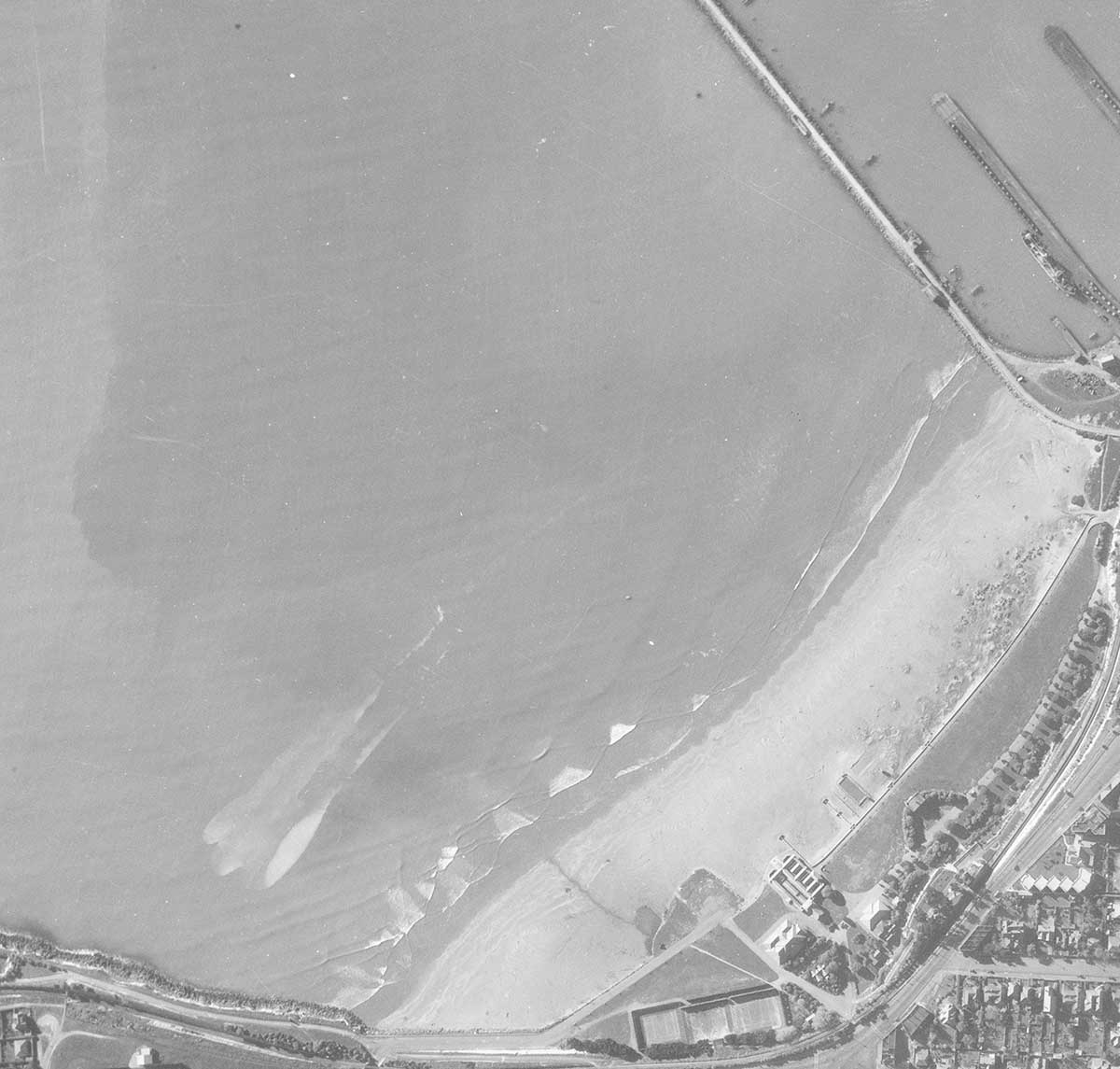
It was always easy to recognise Timaru in the images by seeing Caroline Bay and The Loop. Initially I’d be reminded of a holiday I had here as a teenager, later I’d think “hey, I’ve got family there” and as retirement approached it would be “I’ll be living there soon”.
I retired and shifted to Timaru when there was still about six months of scanning left. As the end approached, LINZ said that they didn’t want it to go into another financial year, so it had to be finished by 30 June 2023. The colleagues I left behind pulled out all stops and finished it on the 29th.

Changing views over Caroline Bay, Timaru. Retolens
Some memories:
There were a few films that hadn’t been washed properly back when they were first processed sixty years earlier. The smell when we opened their containers just about knocked us over and it went home with us in our clothes. A dentist adjacent to our scanning room called in someone to check the building sewerage in case that was where the smell was coming from. Fortunately, we were just operating with a skeleton staff in the office as it was Covid times. The smell actually found its way upstairs where normally there’d be about 80 staff working and clients visiting.
Some of the films were copies made from originals that had the potential to spontaneously combust. I asked a colleague what happened to the original films. “Oh, we took them to the beach and burnt them. The next high tide took it all away.” This was probably in the 1970’s or 80’s. It would be unthinkable to do that these days.
A few things were censored – wartime photography of Waiouru and the surrounding military area was whited out. Another film of a city had a small section cut out of it. It was in Hastings, and we had no idea why it was removed.
We provided an image that blew away the defendant’s case in a historical and serious crime. The defense was that it couldn’t have happened where and when it was alleged as the shed it was claimed it happened in wasn’t built at that time. An image we supplied was able to prove it was.
I learnt a cool word – boustrophedonic. That means going one way and then another. Each frame was scanned in small sections, firstly left to right, then right to left etc. Apparently, we should mow our lawns boustrophedonically.
Before the scanned images were available via Retrolens, we were selling them to the public. A potential customer asked if we had any aerial photography from the 1800’s. “There was some taken from a hot air balloon in Paris” my colleague replied.
A bit about me – not quite three score and ten years old, born and raised in Invercargill, moved to Napier for two years, moved to Hamilton for two years, then back to Napier for more than 40 years. I thought the moves to Napier were the best moves in my life until my wife and I moved to Timaru just ten days before Cyclone Gabrielle hit our former area. We are very happy living here, not as warm as Napier but it’s way better.
I hope you’ve enjoyed this read.
Graeme Gunn
Piet van Asch created the view, pioneering aerial mapping when it was a bold, experimental idea. And the writer of this blog, Graeme Gunn preserved the view, ensuring van Asch’s photographs survived into the digital age through the Retrolens project. Together they represent the start and the safeguard of a national visual memory — the one who flew it, and the one who saved it. - Roselyn Fauth - WuHoo Timaru

Piet van Asch poses at his desk in the offices of New Zealand Aerial Mapping Limited in the mid-1950s.
The aerial photographs that Graeme Gunn helped digitise were originally taken by New Zealand Aerial Mapping Ltd (NZAM), the Hastings-based company founded in 1935 by Piet van Asch. For nearly eighty years, NZAM’s pilots and aerial photographers flew purpose-built aircraft across New Zealand and beyond, capturing precise survey images for the Crown and private clients. Each flight was a team effort, with a pilot keeping the plane steady while a navigator-photographer operated a large-format mapping camera mounted beneath the aircraft. Their work documented farms, towns, coastlines, and even Pacific islands and parts of Antarctica, creating a remarkable visual record of the nation’s changing landscape. When NZAM went into liquidation in 2014, around 650,000 images remained on film — the archive later digitised and preserved by Graeme Gunn and his colleagues at Opus International Consultants (now WSP) for Land Information New Zealand, forming today’s Retrolens collection.
- Sourced from a biography, written by Matthew Wright, was first published in the Dictionary of New Zealand Biography in 2000.
Piet van Asch – Quick Facts
-
Full name: Henry Piet Drury van Asch (1911 – 1996)
-
Born: 4 May 1911 at Waitōtara; raised on Craggy Range farm near Havelock North
-
Education: Christ’s College, Christchurch (1925 – 1929)
-
Early passion: Developed interests in photography and flying while at school
-
First aerial photos (1931): Oblique views of Whakatu Freezing Works and Iona College — both sold commercially
-
Pilot licence: Gained ‘A’ licence in 1934
-
Founded: New Zealand Aerial Mapping Ltd (NZAM) in 1935 — New Zealand’s first dedicated aerial survey company
-
Aircraft: Purchased a Monospar ST-25 Universal (“Manu Rere”) in 1936 for mapping work
-
World War II: Mapped New Zealand for the RNZAF using a Beechcraft AT-11 Kansan — the first new military plane supplied to a civilian firm
-
Flying hours: Logged more than 6,700 commercial hours before retiring in 1980
-
Honours: MBE (1953), CBE (1979); Honorary member of the NZ Institute of Surveyors; Fellow of the Royal Aeronautical Society
-
Community roles: Rotarian (50 years membership); Director of Hawke’s Bay Newspapers; Outward Bound Trust council member
-
Family: Married Diana Other Wright (1940–div.); later Dorothy Freda Kennedy (1980); four children
-
Died: 27 October 1996 in Hastings, aged 85

The first aircraft Piet van Asch bought, in 1936, was a Monospar ST-25 Universal which he named Manu Rere. https://teara.govt.nz/en/biographies/5v1/van-asch-henry-piet-drury
Diana Other Wright (1918–2007) was the first wife of Piet van Asch. They married in 1940 18 December at St Luke’s Church, Havelock North. She was the daughter of Major H. S. Wright. Diana shared much of Piet’s early life during the formative years of NZAM in Hastings. I am not sure she directly worked in the business, but m,ostly likefly she supported a career that blended pioneering aviation, photography, and entrepreneurship. Like many wives of early aviators, I imagine she managed domestic and social duties that enabled the enterprise to thrive. It would be lovely to know more about her. Together, Diana and Piet had three daughters and one son. While Diana is mentioned in van Asch’s biography.
Dorothy Freda Kennedy was Piet’s second wife, and they married in 1980 (née Ulmer) in Westminster, London. Dorothy married Piet in his retirement years, after his CBE (1979) and long mapping career. Dorothy outlived Piet. she is buried in Wellington, New Zealand.

NZ Aerial Mapping staff David Napier, Carol Napier and unknown person - NZ Aerial Mapping Ltd https://knowledgebank.org.nz/still_image/david-and-carol-napier


Man working at NZ Aerial Mapping, corner of Queen Street and Avenue Road East, Hastings

“A great step forward on the earlier Multiplex plotters, this first order A8 stereo plotter from the stable of Wild is shown being assembled at NZAM in Hastings by Swiss engineer Joe Bruilhart.” From “Piet’s Eye in the Sky” by Piet van Asch, page 129
Graeme Gunn worked on digitising New Zealand’s historic aerial survey films for Land Information New Zealand (LINZ) while employed by Opus International Consultants (later WSP) in Napier. After New Zealand Aerial Mapping went into liquidation in 2014, Opus won the tender to scan about 1,500 rolls of film containing 650,000 images. Graeme joined the project around 2016, drawing on his photography knowledge and later becoming project lead. He continued the meticulous scanning and quality-assurance work until his retirement in 2022, shortly before the archive’s completion. The digitisation was finished on 29 June 2023, preserving nearly a century of aerial imagery that now forms the publicly accessible Retrolens collection.
WuHoo Side Quest: Were there other aviation companies taking photos?
Whites Aviation Ltd is another example of a New Zealand aerial survey and photography company, and it forms an important parallel to New Zealand Aerial Mapping (NZAM), though the two operated with slightly different purposes and styles.
Founded in 1945 by Leo Lemuel White (1906–1967), Whites Aviation specialised in aerial photography and publishing, producing extensive visual coverage of New Zealand and the Pacific from both air and ground. While NZAM’s focus was on precise aerial survey mapping for the Crown and technical users (engineers, planners, geologists), Whites Aviation created more public-facing imagery — beautiful oblique aerial views and scenic photographs that were widely distributed through books, postcards, and pictorial reference series such as White’s Pictorial Reference of New Zealand.
The company’s collection spans 1907–1988 and includes about 80,000 negatives and 55,000 prints, now held by the Alexander Turnbull Library. Its coverage ranges from New Zealand towns and landscapes to the Pacific Islands, Antarctica, and even Asian destinations photographed for airlines in the 1940s–50s. Whites Aviation also documented aviation history, industries, rural life, and transport — offering a broad social and visual record of mid-20th-century life.
After Leo White’s death, the company changed hands several times — eventually becoming part of GeoSmart (now Aerial Surveys Ltd), a direct descendant still active in aerial mapping and geospatial imaging today.
So, while Piet van Asch’s NZAM created systematic, scientific aerial surveys that underpinned modern mapping (and were later digitised by Graeme Gunn and his team for the Retrolens project), Leo White’s Whites Aviation captured the artistic and documentary side of aerial photography — the evocative views that shaped public imagination and national identity. Together, they represent the technical and cultural twin pillars of New Zealand’s aerial photographic heritage.
- https://natlib.govt.nz/records/22874066
WuHoo Side Quest: Who uses these images today?
The historic aerial photographs digitised through the Retrolens project are now a national treasure — used by everyone from scientists to storytellers. Managed by Land Information New Zealand (LINZ) and co-funded by regional councils including Environment Canterbury, Timaru District Council, and others, the Retrolens archive gives open access to more than 600,000 aerial images dating back to the 1930s. Local authorities and engineers use them to plan infrastructure and monitor environmental change; researchers and educators study how landscapes, wetlands, and coastlines have evolved; and historians, heritage advocates, and curious locals explore how towns once looked. What began as a technical preservation project has become a public time machine — helping all New Zealanders see how the land beneath their feet has changed through time.